Arundo donax: Impacts and Distribution
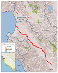
From 2008-2010, Cal-IPC mapped Arundo donax at high resolution on all coastal watersheds in California from Monterey to San Diego. Impacts from Arundo invasion were calculated over the study area, including impacts to biomass production, water use, fire, geomorphic and fluvial processes, and endangered species. New findings include documentation of fire events starting in Arundo stands and significant modification of fluvial processes. All impacts are quantified over the study region and by individual watershed. The study determines a typical benefit-to-cost ratio of 2:1 for Arundo removal projects.
Download the report
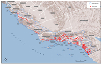
Appendix A contains maps of Arundo distribution.
- Full Arundo Donax report (252 pp., 7.7 MB pdf)
- Front pieces and Executive Summary
- 1. Introduction and 2. Arundo Biology
- 3. Spatial Data Set: Monterey to Mexico
- 4. Impacts of Arundo: Arundo water use and stand transpiration
- 5. Impacts of Arundo: hydrology, geomorphology, and flooding
- 6. Impacts of Arundo: fire
- 7. Impacts of Arundo: federally endangered and threatened species
- 8. Cost to Benefit Analysis
- 9. Watershed-based Arundo Control Programs
- 10. Summary of Data and Literature Cited
- Appendix A. Detailed Maps of Arundo Distribution
- Appendix B is broken into three files for easy download
Appendix B shows federally listed species
Download the data
- Arundo donax GIS geodatabase (Full file size is 55 MB.)
- Hydrologic analysis by northwest hydraulic consultants, inc.