 This report summarizes results from an extensive Arundo mapping effort in California’s Central Valley, which includes the surrounding foothills. Using the mapping dataset as a basis, we estimate Arundo’s impacts in each of 25 watershed units across the region and assess the relative benefits of removal in each unit. We then integrate the impact for each watershed unit with an assessment of local capacity to build and implement a long-term Arundo removal program. (Local capacity is critical—it is a big lift to secure permits and landowner access authorization, implement control work, and build a system for consistent long-term follow-up up for a minimum of 10 years.) From these integrated factors we suggest priorities and make management recommendations.
Download the Report
This report contains large files. It is broken into two separate files, one zipped folder and one PDF.
Click here to download the PDF of Appendices A and B (57.3MB)
Contents:
-
-
-
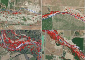
Abundant and patchy distribution of Arundo in braided stream systems along (clockwise from upper left): Thomes, Elder, Cache, and Stony Creek.
Executive Summary
- 1. Arundo Biology, Physiology, and Physical Structure
- 2. Arundo Ecology
- 3. Arundo Distribution in the Central Valley
- 4. Impacts on Water Resources
- 5. Impacts on Geomorphology
- 6. Impacts on Fire
- 7. Impacts on Sensitive Species
- 8. Cost-Benefit Analysis
- 9. Management Recommendations
- Appendix A – Maps of Watershed Units
- Appendix B – Sensitive Species Accounts
- Appendix C – Sensitive Species Maps
- Appendix D – Management Notes by Watershed Unit
-
-
Download the data and information (published March 2019)
Arundo in the Central Valley dataset (GIS shapefile)
Large format overview map of Arundo in the Central Valley
Please cite this report as: California Invasive Plant Council [Cal-IPC]. 2020. Central Valley Arundo: Distribution, Impacts, and Management. Final Report to the State of California Wildlife Conservation Board, Agreement No. WC-1561MM. Available: www.cal-ipc.org
For more information, contact Cal-IPC.